


Geospatial Data Benefiting Air Navigation Pro Flight Planning App
Learn how Air Navigation Pro integrates advanced geospatial data to optimize flight planning, enhance situational awareness, and deliver a safer, more efficient flying experience for pilots.
THE CLIENT - Air Navigation SA
The company Xample was created in Switzerland in 2008 by Johann Huguenin, a developer, and Visual Flight Rules (VFR) pilot. By merging his two passions, he developed a flight planning solution only for his own needs. The application called Air Navigation was then published on the App Store and became a dazzling success simply by word of mouth of pilots.
Johann surrounded himself with a dedicated team of passionate pilots and developers with whom he later achieved to add a hundred more features to the app. All of these make the pilots experience smoother and safer in many cases.
Air Navigation Pro is now a high-quality flight planning and real-time aircraft navigation application for individual and professional pilots all over the world. It allows VFR pilots to have more information about the area they are flying through. Pilots can easily plan and track their flights inside the app. Some of its main features are:
- Moving Map: Showing real-time navigation values.
- Weather: Display of wind, cloud and rain information, etc.
- Elevation: Elevation profiles, terrain awareness and warning system.
- Traffic Awareness: Locally detected traffics shared with other users through GSM connection.
THE CHALLENGE - VFR Pilots Flying Through Unfamiliar Terrain
Flight assistant applications are increasingly used by pilots for real-time flight planning and monitoring. They meet strong and essential challenges in terms of safety and performance.
The challenge faced by helicopter and small aircraft pilots was the need for navigation using external landmarks. These pilots often rely on visual cues such as forests, lakes, and other physical features to determine their location and orientation in flight. However, this method of navigation can be difficult, especially when flying in unfamiliar terrain.
To address this issue, it was desired to provide a solution that would allow pilots to preview their flight path using reliable 2D and 3D geospatial data and familiarize themselves with the environment in advance. This would improve their situational awareness, enabling them to quickly identify potential hazards such as mountains. That would ensure that pilots always have a clear understanding of the environment.
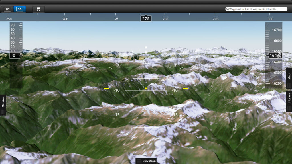
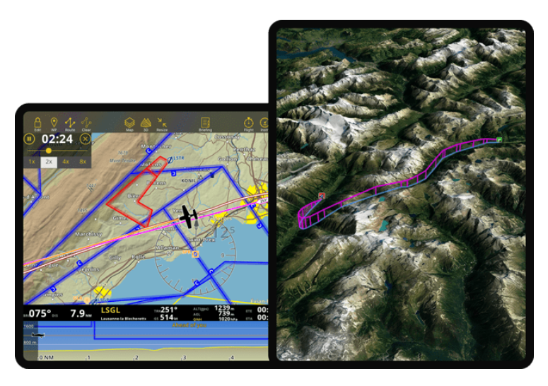
THE SOLUTION - 2D + 3D Geospatial Data for Air Navigation Pro App
The solution to this challenge was the implementation of a 3D view, which provides a detailed and interactive visual representation of the flight path and surrounding environment, making it easier for pilots to navigate and make informed decisions during flight. To create this 3D view, PlanetObserver provided two global datasets, PlanetSAT 10m satellite imagery basemap and PlanetDEM 90m elevation data. Both combined, they make an extremely reliable medium-resolution 3D map which is affordable for this type of app.
Why did Air Navigation SA choose PlanetObserver products?
The development team conducted extensive research on various datasets. They ultimately determined that the satellite imagery and elevation data from PlanetObserver were the most comprehensive and error-free for global coverage. This was due to the continuous efforts put in to ensure the reliability and accuracy of these datasets.
Furthermore, it was necessary to choose data available offline. This was because pilots often fly in areas with limited or no access to mobile network. PlanetObserver datasets met this requirement, providing offline access to their satellite imagery and elevation data.
« We believe pilots should always fly with the safest and most accurate aeronautical data possible, which is why we created Air Navigation Pro subscriptions and provided PlanetObserver 2D and 3D reliable data .»
Johann Huguenin, CEO of Air Navigation SA
THE BENEFITS - The Pilot’s Experience
Air Navigation SA acknowledges that the integration of PlanetObserver’s 3D global view into the Air Navigation Pro flight assistant app did significantly enhance the flight experience for pilots.
Benefits include:
- Increased pilot experience: Pilots notice a difference in the quality of the maps, giving them more confidence in the data they are using.
- Increased security: Thanks to a better understanding of the environment, flight safety is increased for pilots.
- Realistic: Pilots get an accurate representation of the landscape they will be flying through.
- Time saving: Pilots directly benefit from the 3D views. They save time when preparing their flight.
Discover more Customer Success Stories
Let's talk
Ready to enhance your project with high-quality geospatial data? Talk to our team to get started.
