


High-Quality 3D Terrain Simulation Imagery for Terra Vista
Discover how high-quality 3D terrain simulation imagery enhances Terra Vista workflows, delivering realistic environments, improved modeling accuracy, and more effective mission preparation.
Key benefits
1. Strengthened Product Offering
The integration of PlanetSAT and PlanetDEM in Terra Vista software provides Agenium with a competitive edge in the 3D terrain simulation market. The software now comes with high-quality, global satellite imagery and elevation data out of the box—enhancing its appeal to a broader client base and reinforcing Agenium’s position as a key player in terrain simulation.
2. Market Expansion Through Flexible Access Models
For Agenium, this partnership enhances the overall value proposition of Terra Vista, allowing the company to deliver a more comprehensive and scalable solution to its clients. The availability of both freemium and premium tiers creates new revenue opportunities, enabling wider market reach—from entry-level users to high-end simulation professionals. This flexibility supports diverse customer needs without additional development costs.
3. Faster Deployment and Simplified Integration
The technical readiness of PlanetSAT and PlanetDEM datasets, fully compatible with Terra Vista workflows, helps reducing integration time and operational overhead for Agenium.
4. Ongoing Product Relevance
The annual updates of the 10-meter PlanetSAT imagery ensure that Terra Vista remains aligned with evolving user expectations, offering current and visually consistent terrain data essential for mission-critical applications. This helps Agenium develop its position in the real-time terrain generation market and develop long-term customer satisfaction and retention.
5. Enhanced Customer Satisfaction and Retention
The improved user experience—from effortless setup to high visual fidelity—helps Agenium deliver more value to its clients. This contributes to long-term client relationships and supports future product adoption across markets.
Products used
The client : Agenium and Terra Vista: Advancing 3D Terrain Simulation
Agenium Group is a French technology company specialized in high-performance simulation and training systems, with a strong presence in the defense and aerospace sectors. Ten months ago, the company has acquired the Terra Vista business from Canadian company CAE Inc —a strategic move aligned with its growth strategy to deliver innovative solutions for 3D terrain simulation.
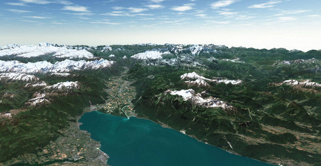
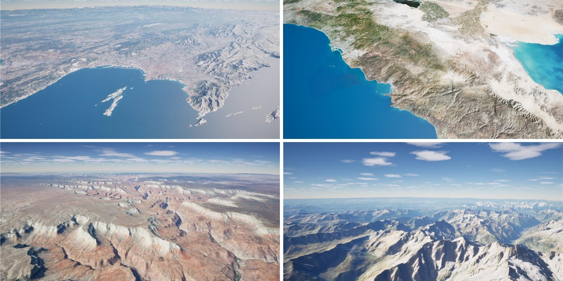
Terra Vista is a powerful software solution designed to generate realistic 3D terrain environments for military and civil aviation training, mission planning, and visualization applications. It is recognized for its capability to support real-time rendering requirements in complex 3D simulation environments.
Agenium serves a broad portfolio of defense contractors, government agencies, and aviation professionals seeking reliable, adaptable tools for terrain generation and immersive simulation.
The Challenge : Delivering Global, Realistic Terrain Imagery for 3D Simulation
Terra Vista users increasingly demand access to high-quality satellite basemaps and elevation data that can meet the specific needs of simulation environments, from military training to emergency response and air navigation. Until now, many users faced limitations in acquiring global geospatial data that met both visual realism and integration standards for real-time simulation.
The challenge was to source a global 3D terrain simulation imagery solution that is:
• Visually consistent and color-balanced
• Easy to deploy within the Terra Vista platform
• Scalable to meet both standard and high-end requirements
• Cost-effective with flexible licensing
To meet these expectations, Agenium needed a reliable and capable data partner.
The Solution : PlanetSAT and PlanetDEM: Seamless Integration for Enhanced 3D Terrain Generation
To address users’ need for high-quality global geospatial data, PlanetObserver and Agenium established a strategic partnership to integrate PlanetSAT satellite imagery and PlanetDEM global elevation dataset directly into the Terra Vista 3D terrain generation software.
From a technical standpoint, the collaboration offered the Agenium team flexibility in selecting the most suitable file formats for their workflows. PlanetSAT imagery is available in multiple industry-standard formats—including GeoTIFF, Cloud Optimized GeoTIFF (COG), and JPEG 2000—enabling smooth pre-processing and simplified integration into a new Terra Vista postal. This compatibility allowed the data to be operational within Terra Vista quickly and efficiently.
From a business perspective, the partnership introduces two levels of data access for Terra Vista users:
• A freemium package, which includes a 150-meter global imagery basemap combined with a 300-meter elevation model for all users—ideal for general 3D terrain context.
• A premium service, which offers access to 10-meter PlanetSAT global imagery, updated annually, and 30-meter PlanetDEM global elevation data—perfect for more advanced simulation projects.
Both PlanetSAT imagery and PlanetDEM elevation datasets are pre-processed, and immediately compatible with Terra Vista workflows for a ready-to-use experience. This plug-and-play solution allows users to focus on terrain modeling and simulation without any need to manage data preparation. The result is an efficient, scalable solution that enhances realism and usability across a wide range of 3D simulation environments.
« With PlanetObserver data integrated into Terra Vista, we’re empowering our users with a more immersive and accurate simulation experience—one that drives better decision-making and operational readiness,”
Joël Castets at Agenium.
The Benefits : Strategic Value for Agenium and the Terra Vista Ecosystem
1. Strengthened Product Offering
The integration of PlanetSAT and PlanetDEM in Terra Vista software provides Agenium with a competitive edge in the 3D terrain simulation market. The software now comes with high-quality, global satellite imagery and elevation data out of the box—enhancing its appeal to a broader client base and reinforcing Agenium’s position as a key player in terrain simulation.
2. Market Expansion Through Flexible Access Models
For Agenium, this partnership enhances the overall value proposition of Terra Vista, allowing the company to deliver a more comprehensive and scalable solution to its clients. The availability of both freemium and premium tiers creates new revenue opportunities, enabling wider market reach—from entry-level users to high-end simulation professionals. This flexibility supports diverse customer needs without additional development costs.
3. Faster Deployment and Simplified Integration
The technical readiness of PlanetSAT and PlanetDEM datasets, fully compatible with Terra Vista workflows, helps reducing integration time and operational overhead for Agenium.
4. Ongoing Product Relevance
The annual updates of the 10-meter PlanetSAT imagery ensure that Terra Vista remains aligned with evolving user expectations, offering current and visually consistent terrain data essential for mission-critical applications. This helps Agenium develop its position in the real-time terrain generation market and develop long-term customer satisfaction and retention.
5. Enhanced Customer Satisfaction and Retention
The improved user experience—from effortless setup to high visual fidelity—helps Agenium deliver more value to its clients. This contributes to long-term client relationships and supports future product adoption across markets.
The integration of PlanetSAT satellite imagery and PlanetDEM elevation data into Terra Vista marks a strategic step forward for Agenium in the 3D terrain simulation market. This partnership delivers immediate value through enhanced visual realism, global data coverage, and flexible access models—key factors for serving a diverse user base.
By offering seamless integration and regularly updated datasets, Agenium strengthens its product offering while ensuring that Terra Vista remains a high-performance, future-ready solution for mission-critical simulation and training environments.


Let's talk
Ready to enhance your project with high-quality geospatial data? Talk to our team to get started.
