


Satellite Imagery Elevating Moving Maps in IFE Solutions
Discover how high-quality satellite imagery enhances moving map experiences in In-Flight Entertainment (IFE) solutions, offering passengers a more immersive and realistic view of the world.
Key benefits
Using PlanetSAT basemap in Flightpath3D IFE solution provides numerous benefits.
1. Superior Visual Quality: The imagery basemap provided by PlanetObserver offers an enhanced quality with an unrivalled color balance and rich geographical information.
2. Increased level of realism: The use of PlanetSAT basemap not only enhances the visual experience for passengers, but also provides a more comprehensive and up-to-date view of the world, which can be used to offer a wider range of content and services.
3. More engaging content for passengers: The enhanced quality of the satellite maps provided by PlanetObserver, combined with the services and content offered in Flightpath3D IFE application, results in a seamless and intuitive user experience for passengers.
4. Easy-to-integrate basemap: PlanetSAT comes in a number of formats that can be easily integrated in any solutions, thus reducing development and production costs for Flightpath3D.
Products used
The client : Flightpath3D
Flightpath3D is a US leader in the development of innovative inflight entertainment solutions (IFE). Flightpath3D is a comprehensive IFE system that is designed to enhance the travel experience for passengers. The solution is designed to be intuitive and easy to use, providing passengers with a wide range of options, including interactive games, quizzes, social media integration, and real-time flight information. The solution provides an interactive map that allows passengers to see their location in real-time and track the progress of their flight.
Flightpath3D is already used by more than 30 airlines worldwide and is used by millions of passengers. It is a solution that allows airlines to offer a more personalized and engaging experience to their passengers and stand out in a highly competitive market.
The Challenge : How to Enhance Airline Passenger Experience
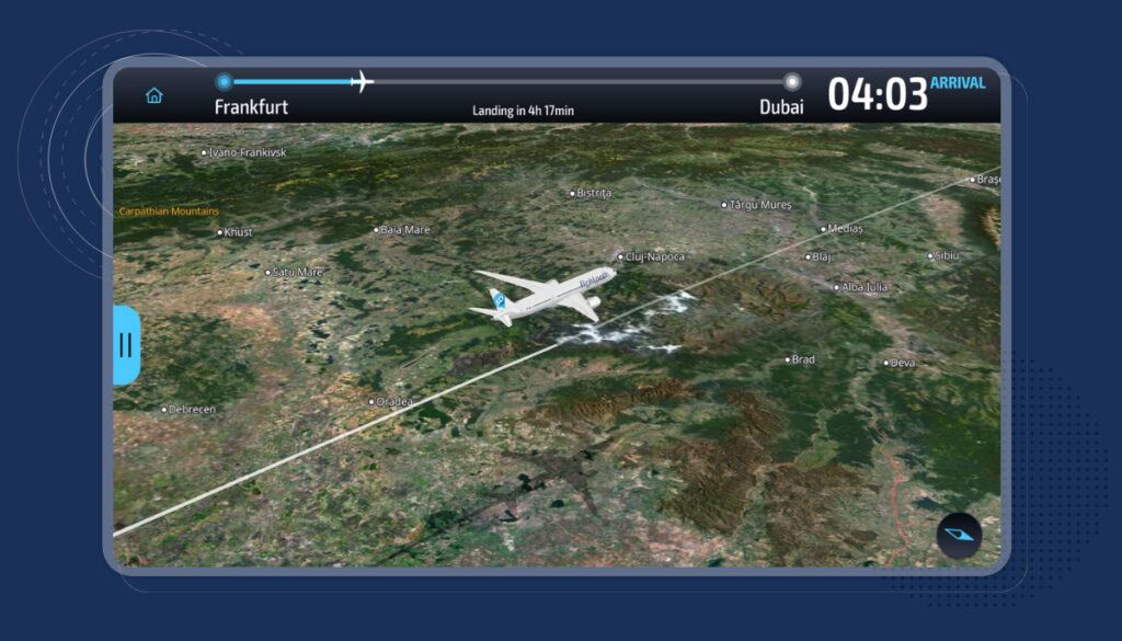
Flightpath3D offers a very innovative 3D moving map application in its IFE solution. What is actually a moving map? It’s the map that every passenger can display to see the aircraft flight path and the plane’s location.
According to a study quoted by Duncan Jackson, President of Flightpath3D, over 67% of the passengers visit the map at least once. On average, passengers visit at least seven points per flight.
One of the levers chosen by Flightpath3D is to enhance passenger experience by enriching the moving map app with high quality cartographic backdrop. The target is to offer passengers highly realistic and attractive views of all overflown areas.
The Solution : Moving Maps, the New Competitive Advantage
To achieve that goal, Flightpath3D is not only looking for enhanced satellite imagery backdrop but also for the proper service so that they can get ready-to-use maps customized according to their specifications.
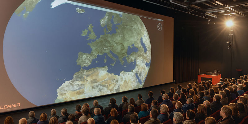
Flightpath3D has set up certain technical specs in terms of imagery resolution and quality, both for land and sea. Indeed, the full world view needs to be attractive as this is the first image that passengers of long-haul flights get to see. The requested satellite maps have to be eye-catching and reflect landscape diversity.
Flightpath3D has contacted PlanetObserver in order to evaluate at first the quality of our global imagery basemap PlanetSAT Global. Flightpath3D had numerous issues:
- Will this imagery product in natural colours bring the required sexy touch to their application?
- Can a special processing be applied on ocean and sea?
- Can we deliver the data on time?
We’ve reviewed all issues together in order to provide the most efficient solution to Flightpath3D. In the end, Flightpath3D has integrated our imagery basemap in its application and brought that way the desired sexy touch.
The Benefits : More than 30 Airlines with 200M Passengers Love our Maps!
Using PlanetSAT basemap in Flightpath3D IFE solution provides numerous benefits.
1. Superior Visual Quality: The imagery basemap provided by PlanetObserver offers an enhanced quality with an unrivalled color balance and rich geographical information.
2. Increased level of realism: The use of PlanetSAT basemap not only enhances the visual experience for passengers, but also provides a more comprehensive and up-to-date view of the world, which can be used to offer a wider range of content and services.
3. More engaging content for passengers: The enhanced quality of the satellite maps provided by PlanetObserver, combined with the services and content offered in Flightpath3D IFE application, results in a seamless and intuitive user experience for passengers.
4. Easy-to-integrate basemap: PlanetSAT comes in a number of formats that can be easily integrated in any solutions, thus reducing development and production costs for Flightpath3D.

Let's talk
Ready to enhance your project with high-quality geospatial data? Talk to our team to get started.
