
Products
Industries
Resources

As visitor expectations for immersive and educational experiences grow, scientific parks and planetariums increasingly turn to high-quality geospatial data to enrich their storytelling.
Vulcania, a unique educational theme park located in the Auvergne region of France, is dedicated to exploring planet Earth and its natural phenomena, with a special focus on volcanology, geology, and space science. The park combines entertainment with science education to engage a wide audience, from families to school groups. Its innovative approach to learning encourages curiosity, providing visitors with an interactive journey through the planet’s mysteries, from the depths of volcanoes to the vastness of outer space.
Through its different exhibitions, Vulcania aims to promote a deep understanding of Earth’s most extraordinary processes. The park uses immersive multimedia displays and interactive exhibits to bring scientific concepts to life in ways that are both engaging and educational. By blending scientific information with captivating visuals and animations, Vulcania ensures that visitors of all ages walk away with a greater understanding of the complexity and beauty of our planet.
In its permanent exhibition “Planète Dévoilée” (Planet Unveiled), Vulcania seeks to provide visitors with a comprehensive and immersive understanding of Earth through spectacular visual content.
The challenge lies in the need for a high-quality Earth basemap that not only supports the educational goals of the exhibition but also enhances the immersive experience for visitors. The map must be both visually captivating and scientifically accurate to ensure it resonates with diverse audiences, from curious children to experts in the field. The goal is to present Earth-related phenomena with visually engaging, scientifically accurate content that can be easily integrated into display systems.
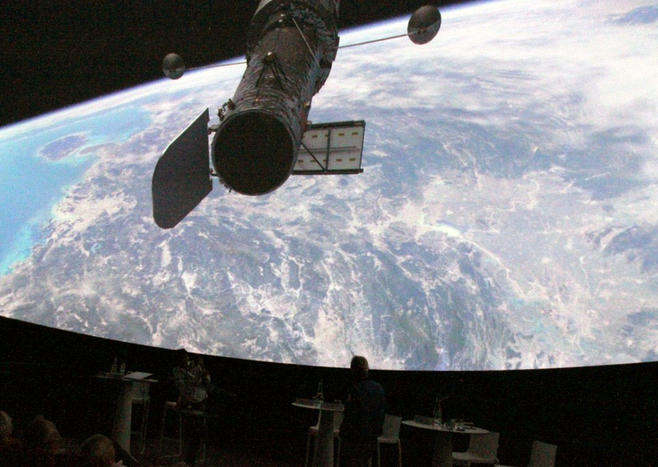
Another major challenge is the newly added planetarium, which aims to enhance the visitor experience by exploring both Earth and other planets in the Solar System. It's important to stress out that this planetarium is the biggest in France with a 22m dome, 1,500 sq meter of projection, and its 306 seats! This addition brings a new layer of complexity, as it requires dynamic and engaging content that blends scientific accuracy with interactive elements. The planetarium not only offers an educational experience but also strives to present this information in a fun and accessible way, ensuring that visitors of all ages can connect with the science behind natural phenomena both on Earth and beyond.
To enhance both its exhibition Planète Dévoilée (Planet Unveiled) and the planetarium experience, Vulcania chose the PlanetSAT Basemap, a high-quality global satellite imagery mosaic at a 10-meter resolution from PlanetObserver. This solution was selected to provide the precision, clarity, and scale necessary for immersive, large-scale visual experiences.
Why PlanetSAT Earth Basemap?
✅ Medium resolution (10-meter) perfectly suited for the global scale: PlanetSAT delivers detailed satellite imagery that is ideal for large-scale projections and installations, ensuring that the visuals remain clear and impactful when displayed in the expansive exhibition spaces and the planetarium dome.
✅ Cloud-free and color-balanced imagery: The imagery is processed to be cloud-free and color-balanced, which guarantees consistent, high-quality visuals. This is particularly important for public displays, where clarity and visual appeal are key to engaging diverse audiences.
✅ Regular updates: PlanetSAT imagery is regularly updated, ensuring that Vulcania benefits from the most current and accurate satellite data. This allows the park to provide visitors with fresh, scientifically reliable content that reflects the latest Earth observations.
The PlanetSAT Earth basemap offers natural-color satellite views of Earth, processed for immediate integration into multimedia environments. The imagery is tailored to meet the needs of educational and immersive settings, creating dynamic visual narratives.
In Planet Unveiled, PlanetSAT imagery serves to illustrate global geological and environmental processes, transforming complex scientific concepts into accessible and visually captivating animations that are easy to follow for visitors of all ages.
In the planetarium provided by RSA Cosmos, PlanetSAT imagery is used as the backdrop for immersive visualizations. The high-resolution data is seamlessly integrated into the dome’s projection system, offering real-time, interactive journeys across Earth’s surface. This enables visitors to virtually explore Earth’s landscapes, weather systems, and geological phenomena, creating an engaging and educational experience.

The integration of the PlanetSAT Earth Basemap offers Vulcania several key advantages, enhancing the park's ability to deliver a visually engaging and scientifically accurate experience for its visitors.
1. Powerful Visual Impact for Educational Storytelling
PlanetSAT’s natural and realistic Earth imagery plays a crucial role in supporting Vulcania’s mission of public science education. Visitors gain a cleared understanding of complex concepts like tectonic activity, erosion, and climate zones through intuitive visual content.
2. Consistent Global Coverage
PlanetSAT offers uniform quality and detail across the entire globe, from local views of the Chaîne des Puys to large-scale visualizations of volcanoes and tectonic zones. This consistent coverage ensures that Vulcania can offer coherent educational narratives, whether showcasing specific regions or providing global context. The high-quality Earth basemap enhances the visitor experience by delivering a breathtaking and seamless view of Earth, whether in exhibition rooms or under the immersive planetarium dome.
3. Scientifically Reliable Content
The imagery used by Vulcania is based on up-to-date Earth observation data, processed to ensure geographic accuracy. This scientifically reliable content provides visitors with trustworthy information, making it suitable for educational settings and public science communication. Vulcania can confidently use this data to present Earth’s natural phenomena with the precision required for educational and scientific purposes.
4. Long-Term Partnership and Support
Vulcania benefits from a longstanding relationship with PlanetObserver, receiving responsive and ongoing support to ensure the basemap continues to meet the park’s evolving exhibition and technical needs.
This partnership, which started in 2005, has proven to be a successful collaboration, allowing both Vulcania and PlanetObserver to grow and innovate together. PlanetObserver’s expertise and commitment to service ensure that Vulcania is always equipped with the best resources to deliver cutting-edge educational experiences.
By using PlanetSAT Basemap in both the Planète Dévoilée exhibition and the planetarium, Vulcania has improved its educational experience with a high-quality Earth basemap that combines scientific accuracy with eye-catching visuals. This partnership helps Vulcania continue its mission of inspiring curiosity and understanding of Earth through engaging and trustworthy content, offering visitors a deeper connection with the planet’s natural processes.


