Products
Industries
Resources
In the 3rd episode of our "Meet the Geospatial Team" series, we get to know Bruno as he talks about satellite image color processing.
.jpg)
Meet Bruno Delfour, the talented Graphic Designer at PlanetObserver, with over two decades of experience in enhancing the beauty and clarity of satellite imagery. In this interview, Bruno discusses his role, the advancements in satellite image color processing, and how PlanetObserver uniquely combines technology with human creativity to produce high quality satellite imagery.
Hello there! My name is Bruno Delfour. I began my career in graphic design and eventually found my way into the geospatial industry, which I find really fascinating and engaging. I've been a graphic designer at PlanetObserver for over 20 years now, mainly working on the production of our flagship product, PlanetSAT 10m Satellite Imagery Basemap and its annual updates.
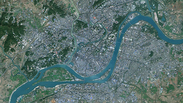
The top satellite images, sourced from Sentinel-2 satellites, are carefully chosen and blended together smoothly to create a clear, continuous mosaic of the world. While much of this process is done automatically through advanced algorithms, we at PlanetObserver take an extra step.
As graphic designers, we use Photoshop to add both an authentic and artistic touch to the images to realistically illustrate earth as it is. It's really valuable to have a human touch in the final stages, allowing us to optimize the color processing procedure and to overcome certain challenges that automated processes may not handle as effectively.
In the realm of satellite image color processing, companies often face significant challenges, particularly when relying 100% on automated methods. At PlanetObserver, we combine both automation and human expertise for our color processing procedures. However, other producers of worldwide satellite image mosaics rely solely on the automated production and color processing. While this approach may offer speed and cost-efficiency, it remains restricted by some difficulties. Automated systems occasionally struggle to flawlessly merge images, resulting in mosaics with visible seams or inconsistencies in color and texture. They can also misidentify or fail to completely remove clouds and shadows. This may create artefacts, no data pixels or composite images with a patchy appearance.
This is precisely why at PlanetObserver, we place a high value on leveraging our expertise into our work. Despite being more time consuming and requiring additional human resources, we recognize these challenges and still opt to pursue in this direction. We are committed to delivering mosaics that are not only seamless, but also vivid with superior quality.
Color processing is highly important as it directly influences the clarity, brightness, and geographic information conveyed in the image. At PlanetObserver, we leverage our expertise to enhance the visual appeal and realism of our images beyond what our competitors offer. Our efforts also guarantee color consistency across all zoom levels, from the global view to the finest 10-meter resolution.
Below is a comparison illustrating the contrast in appearance at the same zoom level between our PlanetSAT 10m Basemap and Google Maps. In the Google Maps image, a predominant green tone complicates the differentiation between vegetation, water bodies, and urban areas. In contrast, the PlanetSAT image showcases richer colors, presenting various shades of green, blue, and gray. Details are more visible, allowing for a clearer identification of diverse terrains. It results in a more vivid and detailed image offering a distinct differentiation between natural and man-made features.

What really makes me happy is knowing that the work I do travels all over the world. From the United States all the way to New Zealand, it's incredible to think that big companies like L3Harris, Thales, and the New Zealand Meteorological Services trust our work. This recognition is a huge accomplishment for me. It makes me love my job even more and motivates me to keep going and never stop!
Wrapping up our chat with Bruno, it's evident that he takes pride in his accomplishments at PlanetObserver. For over 20 years, Bruno has skillfully combined his graphic design expertise with satellite imagery to produce captivating mosaics. Bruno's story highlights the significance of blending our knowhows with technology in what we do to bring out the best results!
Stay tuned for our final episode of the "Meet the Team" series, where we will be interviewing our founder and CEO, Laurent Masselot!